GONE BUT NOT FORGOTTEN
For the last 10 years, Spurtle has been photographing the street-name signs of Spurtleshire.
The aim has been to record their variety of design, aesthetic appeal, interesting history, and the effects of time and human interaction.
Today, we concentrate on the haunting presence of Spurtleshire street names long since passed away.
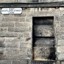
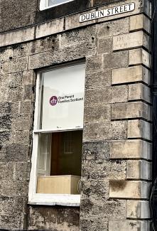
We begin with Duke Street, the name for the south end of today’s Dublin Street from 1802 until 1967. It was dropped to avoid confusion with the Duke Street in Leith.
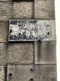
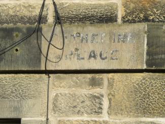
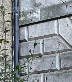
Not many people recall Catherine Place, which used to be the name for the section of road between Huntley St and Boat Green.
It first appeared in the Edinburgh & Leith Post Office Directory of 1864 and housed a number of homes and light-industrial premises until it shrank to its current dimensions around the time of the First World War. The detail below is from Bartholomew's Post Office Plan of Edinburgh, Leith and Portobello (1910–11).
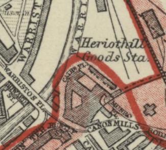
The name continued until 1969, when it was abolished to avoid confusion with West Catherine Place in Coates. The area is now part of Warriston Rd.
The photograph below was taken in 2014. The sign, at the north-eastern end of the surviving building, is currently obscured by foliage.
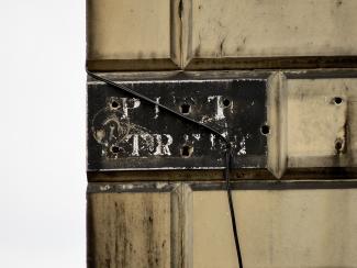
Pitt Street referred to the southern end of today’s Brandon St between 1820 and 1967, being renamed to avoid confusion with another street of the same name in Leith.
Here is all that remains of Claremont Terrace: the run of tenements between today’s 34 and 68 East Claremont Street.
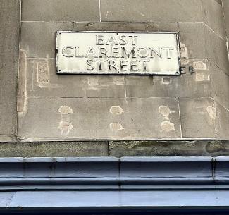
The detail below is from Bartholomew's Post Office Plan of Edinburgh, Leith and Portobello (1910–11).
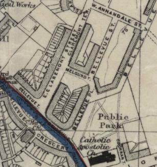
The name was used between 1879 and 1917 but was then discontinued to avoid confusion with a slew of other Claremonts in Stockbridge and Leith Links (see Issue 311, p.4; Issue 312, p.3).
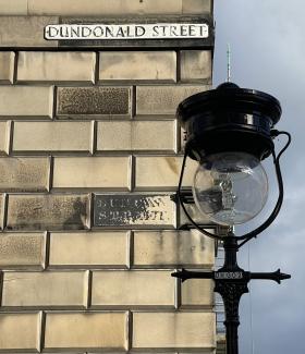
Duncan Street (named after Admiral Adam Duncan) was renamed Dundonald Street (after Rear-Admiral Cochrane, Earl of Dundonald) in 1885 to avoid confusion with the Duncan Street in Newington.
From 1817 to at least 1954, George Place stood next to Pilrig Place on Leith Walk. We have yet to establish the exact date of its disappearance, but the reason was probably to avoid confusion with the George Place in Portobello.
Only the faintest trace remains.
The location is shown in the following detail from the Ordnance Survey of 1852.
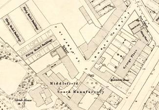
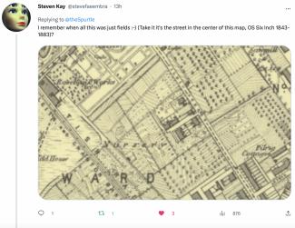
Spurtle has found no trace of St James Street, which ran between Middlefield and (eventually) Dryden Street from about 1816 until it was simplified or secularised as James St around 1864 (see map above). It continued like this until 1965, when it was again renamed, this time as Spey Terrace to avoid confusion with James Street in Portobello.
Similarly lost is Moray Street, which, from around 1816, ran between Pilrig Street and James Street before being renamed Spey Street in 1885 to avoid confusion with Moray Place (see map above). It is unlikely anyone would confuse the two today.
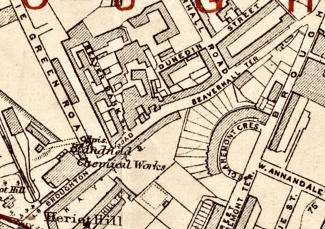
Likewise, no signs remain of Lower Broughton Road between Canonmills and Broughton Point (at the corner of East Claremont Street). It was built in 1735 and retained the name until 1912 when it was almamagated with Broughton Road. The section on either side of Beaverhall Rd known as Beaverhall Terrace has also disappeared from view.
This detail is from Bartholomew's Post Office Plan of Edinburgh, Leith and Portobello (1910–11).
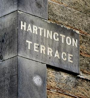
Spencer Cavendish, Marquess of Hartingdon (1833–1908) was at different times a leading statesman in the Liberal, Liberal Unionist, and Conservative Parties. Hartington Terrace was named after him in 1874 before becoming Rosslyn Terrace in 1894 to avoid confusion with Hartington Place in Bruntsfield. The sign shown below survives on a house at the corner with Rosslyn Crescent.
For anyone interested in the origins of other capital place names, we recommend the National Library's collection of Edinburgh and Leith Post Office Directories, and Town Plans, and Stuart Harris' The Place Names of Edinburgh: Their Origins and History (Steve Savage: London and Edinburgh, 2002), ISBN 1-904246-06-0).—AM
If you know of other place-name disappearances or ghostly survivals in Spurtleshire, we’d love to hear from you. Tell us as at spurtle@hotmail.co.uk and @theSpurtle
------------
EILEEN DICKIE WRITES: Hope Crescent became Hopetoun Crescent in 1966, thus losing the historical link with John Hope, Regius Keeper, who moved the Botanic Gardens here from Waverley Station to a new site ‘on the road to Leith’.
Hope Crescent was named to keep his memory alive on the remains of this garden. It was changed in case of confusion with the Hope Park/Street etc on Edinburgh’s South Side. As you say, Stuart Harris (despite all his occasional mistakes) is a fount of knowledge.
‘Hope Crescent’ was painted on the gable end of one of the workshops in the Crescent; I took a photo of it, went away for the weekend, had my camera stolen and when I got back these buildings had all been demolished! I would dearly like to know if anyone has a photo of the name. SPURTLE REPLY: No street-name sign, unfortunately, but an interesting image HERE on Peter Stubb's excellent EdinPhoto website.